Geography in the Genizah, T-S Ar.30.221
Geographical texts in the Collection
Yossi Ben-Artzi, a geographer from the Dept of Israel Studies, University of Haifa, on research leave in Cambridge/Emmanuel College, and Esther-Miriam Wagner
Geographical texts in the Genizah are relatively few, and like many scientific texts, they are mainly translations of Arabic works. Because of their scarcity, none of the researchers at the Genizah Unit is particularly familiar with geographical works, so when Professor Yossi Ben-Artzi, a geographer on research leave in Cambridge, came to the Unit to view Genizah fragments we seized the opportunity to learn more about the topic and worked with him on a fragment that the Polliack-Baker catalogue had identified broadly as ‘geographical’. A look through the indices for further geographical fragments quickly revealed another page of the same work.
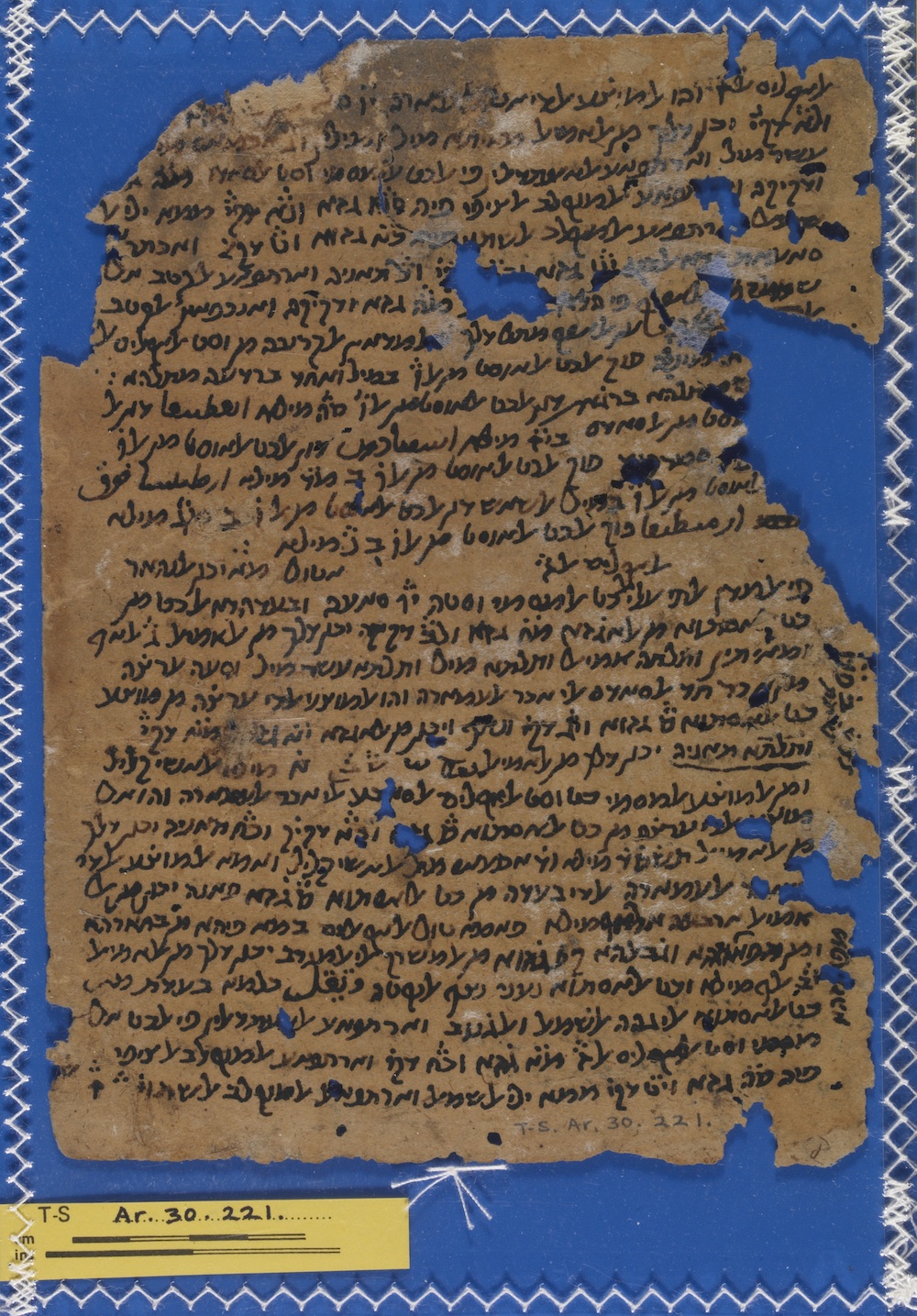
Recto of T-S Ar.30.221
The first fragment, T-S Ar.30.221, references Ptolemy and deals with localities in the sixth and seventh of the so-called Seven Climate Zones, a geographical system commonly used in the medieval era. The basic assumption of this system, which was developed by the earliest geographers and championed by authors such as Ptolemy (90–168 CE), is that the same climatic conditions will be valid for all places and sites which are located on the same latitude, that is measured from the equator but calculated by the length of the longest day rather than degrees of arc (which means that the length of the day increases from 12 hours to 24 hours as latitude rises). Astronomers and mathematicians made complicated calculations regarding the sun, the moon and their related distances and angles of exposure to the earth, and thereby enabled geographers to locate each place to a certain geographical point, indicated by degrees and minutes derived from these calculations.

Verso of T-S Ar.30.221
At the end of the fragment, where a new chapter starts, the last sentence on the page is continued immediately in the second fragment, T-S Ar.44.66. The chapter is concerned with oceanic geography, explaining the location of various seas and their names.
Both fragments share the trait that only a few of the toponyms are written in Hebrew script. In all cases, these are well known places, such as Constantinople or the Red Sea. In many other instances, the writer left the words in their Arabic spelling, without punctutation, as he obviously could not decipher them himself. This is a common phenomenon: even in the modern editions of, for example, al-Ḵuwārizmī’s works, many of the localities, particularly in the far-away higher latitudes, remain unidentified, and only the body of the Arabic word without punctuation is given. Mžik (1926, ix) explains that names in the Arabic geographical works have to be separated into two groups: one rendering Greek names, which were already corrupted in the Arabic copies because the places were unknown to the writers, as opposed to names of the Islamic cultural sphere, which were known to the copyists. The names we find in Hebrew script fall in the latter category, whereas the words that were left in Arabic were very likely already problematic in the Arabic Vorlage.
A few of the Arabic words could with some imagination be correlated to known Greek toponyms, for example the Arabic word in l. 12 on recto might be Artamita or Artaxata in Armenia, or the word in l. 16 of verso may represent a corrupt version of ابيردبين, as mentioned in Ḵuwārizmī’s Kitāb ṣūrat al-arḍ (see p. 33 in Mžik’s edition).
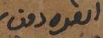
Detail showing the Arabic toponym in recto, line 16 of T-S Ar.30.221
Medieval geography
Ptolemy’s work included tables of the coordinates of thousands of places, with instructions on how to create maps accordingly. Muslim geographers of the Middle Ages partly argued against Ptolemy, suggesting other methods and data sets. An important impetus to the development of Muslim geography and cartography was made by the caliph al-Maʾmūn (786–833 CE). He assigned a group of geographers to re-measure the distance corresponding to one degree of the celestial meridian. They re-defined the mile used by Arabs in comparison to the stadion used by Greeks, thus enabling the calculation of the locations of sites in a different way.
The first major Muslim geographer was al-Ḵuwārizmī (780–850 CE) who reworked Ptolemy’s idea and created a different system of world coordinates and locations, suggesting no less than 2402 location coordinates of geographical names. Most medieval Muslim geographers, for example al-Bīrūnī (973–1048 CE), al-Idrīsī (1099–1165 CE) and Yāqūt (1179–1229 CE), continued to use al-Ḵuwārizmī's system with amendments, but stayed within the paradigm of the Seven Climate Zones.
Similar to our work, Ḵuwārizmī also separated the description of localities in the climate zones from accounts of mountains and the seas, which means our work is very much in the tradition of these earlier works.
The Genizah fragments in context
We were not able to identifiy which work the Judaeo-Arabic text copies and would be grateful for any suggestions. It is very likely that our work was copied from a Muslim, or at least Arabic, Vorlage. Although, there is a small chance that it was composed in Judaeo-Arabic, by someone utilising Arabic works, maps and tables, this is an unlikely scenario. The author of the original work, or possibly of the Judaeo-Arabic copy, may have had more than one text in front of him, compiling information from various sources. From the text it seems that he is describing tables of coordinates, while checking on a list of place-names or a map, which he then inserted into his own text, possibly while also consulting other geographical texts.
The major question that these and other scientific works in Hebrew script raise is for what purposes were the Judaeo-Arabic copies made? It may be assumed that anyone interested in scientific works would have been able to read and work with Arabic script copies. What was the readership of these copies in Hebrew script therefore? Was this an attempt to ‘judaize’ scientific works? Were they made for educational purposes in Jewish schools, or are these merely private copies, which the owner preferred to have in Judaeo-Arabic?
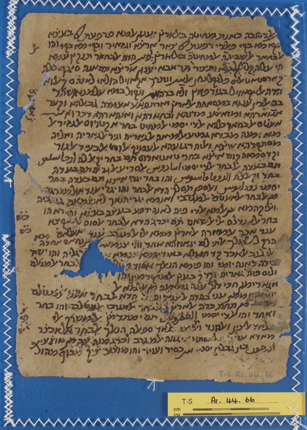
Recto of T-S Ar.44.66
Selected references
Berggren L., and Jones A., Ptolemy’s Geography: an Annotated Translation of the Theoretical Chapters (Princeton, 2000).
Honigmann E., Die Sieben Klimata und die Poleis episimoi (Heidelberg, 1929).
Kennedy, E.S., and M.H., Geographical Coordinates and Localities from Islamic Sources (Frankfurt, 1987).
Mžik, H., Das Kitāb ṣūrat al-arḍ des Abū Ǧaʿfar al-Ḫuwārizmī, volume 3 of Bibliothek arabischer Historiker und Geographen (Leipzig, 1926).
Cite this article
Ben-Artzi, Y., & Wagner, E. (2010). Geography in the Genizah, T-S Ar.30.221: Geographical texts in the Collection. [Genizah Research Unit, Fragment of the Month, December 2010]. https://doi.org/10.17863/CAM.55273
If you enjoyed this Fragment of the Month, you can find others here.
Contact us: genizah@lib.cam.ac.uk
The zoomable images are produced using Cloud Zoom, a jQueryimage zoom plugin:
Cloud Zoom, Copyright (c) 2010, R Cecco, www.professorcloud.com
Licensed under the MIT License