Introduction
In addition to our extensive paper collections it is also possible to access a selection of digital maps online and from within the Map Room.
Ordnance Survey
Cambridge University Library is a legal deposit library and so holds an extensive archive of printed Ordnance Survey (OS) maps. Indeed, except for some of the very earliest 1:2,500 scale maps (published in the second part of the 19th century) the Map Department should have a copy of every OS map ever published.
The most detailed OS mapping is no longer published on paper and can only be accessed electronically. There are two ways – depending on your status and the use to which you want to put the data – to gain access to OS digital maps or map data within the University.
1. Ordnance Survey Map Data in the Map Room
Since 1998 Ordnance Survey has voluntarily deposited an annual snapshot of its most detailed data in the legal deposit libraries, thus ensuring that the record of our changing landscape is not lost. This data is only accessible via a specific computer in the Map Room from which A4 sized printouts can be taken. No data can be downloaded. Find out more here. Ordnance Survey of Northern Ireland, and an increasing amount of other map data, can also be accessed via this dedicated PC
2. Digimap
Digimap delivers online access to Ordnance Survey Map Data to registered users within UK Tertiary Education. Digimap's collections include access to the most recent map data as well as images of historic OS maps dating from 1843 to 1996. The data can be downloaded. To use Digimap you must be a current member of staff or a current student of the University. Other data is also avaiable. Find out more here.
Historic Collections
Many of the Library’s collections are being made available online through the Cambridge Digital Library so that they can be much more accessible to students, researchers and the wider public.
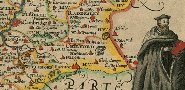
The Map Department is currently represented though its collection of proof maps prepared for John Speed’s Theatre of the Empire of Great Britain plus a growing collection of maps of Cambridge and other parts of the world.
This is an area of development and expansion and we hope to add more maps in the near future. Follow @CamDigLib to be the first to find out about the latest additions to the Digital Library or read the latest news updates here.
Non-University Sources
There are many map images available on the www. Check out some of the resources on our Links pages - modern maps and old maps.
Image credit: extract of Speed's Cambridgeshire from Atlas.2.61.1