Principal Categories of Material Held in the Map Department
- Old Maps, Atlases and Views
- Facsimiles of medieval maps and other old atlases.
- Original maps and atlases by most of the principal British and foreign map-makers from the 16th century onwards.
- Sea charts, in particular old British and French charts.
- Large scale maps, including county maps at the scale of one inch to one mile published before the advent of the Ordnance Survey at the beginning of the 19th century, and town plans.
- Detailed maps and views of the City of Cambridge and of Cambridgeshire parishes.
- Auction particulars of sale of rural estates.
- Topographic views: including old engravings, photographs and postcards. Of some interest are 4 bound volumes at classmarks Views.Cantab.1-4 which include a selection of maps and 19th century photographs of Cambridge Colleges.
- Manuscript maps, including estate plans and railway track diagrams.
- Modern Maps and Atlases
- Ordnance Survey maps; most editions of both the modern National Grid and superseded series at scales from 1:1,250 to 1:1,000,000. (For the 1:2,500 and 1:500 county series, coverage of the first edition, c. 1880-90, is generally limited to East Anglia). The most recent detailed Ordnance Survey maps are accessed electronically in the Map Room, or via the Digimap Service.
- Other British official map series, e.g. Geological Survey, Soil Survey, Directorate of Overseas Surveys.
- British Admiralty Charts - these provide world-wide coverage.
- Local authority development plans and planning reports.
- Major national topographic map series from many parts of the world. The most detailed scale we normally consider acquiring is 1:25,000.
- Commercial map publications, e.g. British and foreign town plans, road maps.
- Thematic maps, e.g. geological maps, soil maps, weather maps. General, national, regional, thematic, historical and linguistic atlases.
- Ancillary Material
- Gazetteers of the world and of individual countries.
- Books on general, regional, and historical cartography; cartobibliographies; catalogues of other map libraries.
- Information about where maps not in the collection may be consulted or purchased.
- Charles Close Society (CCS) Archives
- Technical works, catalogues, publication reports, historical material, papers written for academic journals, of relevance to the Ordnance Surveys of both Great Britain and Ireland.
- Selected files defining the specification of individual series, and master files for individual sheets.
- Files relating to the work of the Directorate of Overseas Survey.
- The collection is listed on ArchiveSearch
- Tips on searching ArchiveSearch
- Further information on the CCS Archives
- For information on the Charles Close Society
Please Note:
- Cartographic periodicals do not stand in the Map Room; order online or ask in the library’s Main Reading Room.
- The Map Room collection does not include books on surveying.
Collection Development Policy
The Library's Collection Development Policy general information of relevance to all sections of the Library as well as a specific section on maps.
Recommendations
Readers are very welcome to recommend items they think we should acquire. Recommendations can be made via the online recommendation form or by email, letter or note.
Named Collections
There are a small number of named collections in the Map Department.
Maps and Plans:
- Harker Collection of maps of Scotland - Maps.Harker
- Lohning collection of oil rig plans - Maps.Lohning
Ordnance Survey Maps and Related Items:
- Charles Close Society Archives
- Messenger Collection - Maps.KGM
Paintings and Drawings:
- Views.Norman
- Views.Relhan
Slides and Glass Plates:
- Mandeville collection of glass plate negatives of Huntingdonshire maps (mostly manuscript)
- Slides.Campbell
- Slides.Steers
- Slides.Watts.
Postcards:
- Peck postcard collection - Views.PC.Peck
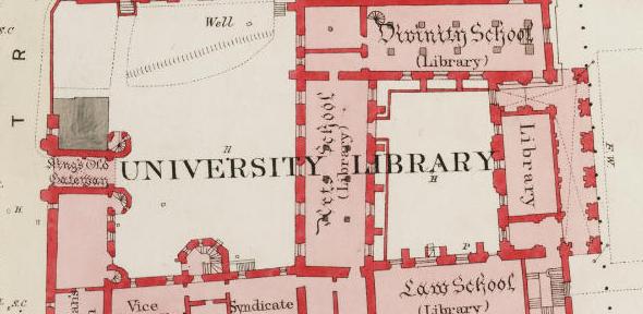
Image credit: Extract from Ordnance Survey 1:500 scale plan of Cambridge published in 1888 (i.e. before the University moved to its present site). Sheet number = Cambridge 26 (XLVII.2.7)